Image credit: David Seibert
Year Erected: 1954
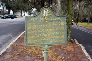
Marker Text: This town was built on the north bank of the St. Marys River at a place called Buttermilk Bluff. Original tract of land containing 1620 acres was purchased by the proprietors for laying out the Town of St. Marys from Jacob Weed for thirty-eight dollars on Dec. 12, 1787. City was first laid out by James Finley, County Surveyor, August 1788 and recorded Jan. 5, 1789. The twenty proprietors of the town were: Isaac Wheeler, William Norris, Nathaniel Ashley, William Ashley, Lodowick Ashley, James Seagrove, James Finley, John Fleming, Robert Seagrove, Henry Osborne, Thomas Norris, Jacob Weed, John Alexander, Langley Bryant, Jonathan Bartlett, Stephen Conyers, William Ready, Prentis Gallup, Simeon Dillingham, Richard Cole.
City laid out second time as authorized by an Act of Dec. 5, 1792. Map of town drawn by Parker, Hopkins, & Meers, certified by James Parker, County Surveyor, Jan. 3, 1792. The town of St. Marys was incorporated by an Act passed Nov. 26, 1802.
St. Marys temporary county seat until first courthouse and Gaol erected at Jefferson (Jeffersonton) as authorized and named in Act passed Nov. 29, 1800. Jeffersonton was permanent county seat for sixty-nine years (1801-1871).
Election held Jan. 3, 1871 authorized by an Act passed Oct. 27, 1870 for removal of county seat from Jeffersonton to St. Marys. St. Marys permanent county seat for fifty-two years (1871- 1923). Act of Aug. 11, 1923 authorized removal of county seat from St. Marys to Woodbine.