Image credit: David Seibert
Year Erected: 1981
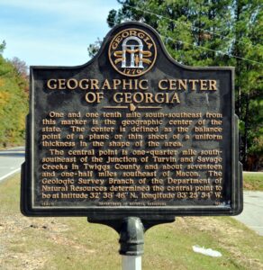
Marker Text: One and one tenth mile south-southeast from this marker is the geographic center of the state. The center is defined as the balance point of a plane or thin sheet of a uniform thickness in the shape of the area.
The central point is one-quarter mile south-southeast of the Junction of Turvin and Savage Creeks in Twiggs County and about seventeen and one-half miles southeast of Macon. The Geologic Survey Branch of the Department of Natural Resources determined the central point to be at latitude 32° 38´ 46" N., longitude 83° 25´ 54" W.
Tips for Finding This Marker: At the intersection of Jeffersonville-Bullard Road and Marion Road, on the right when traveling east on Jeffersonville-Bullard Road in Jeffersonville.
Learn more about the marker here.
Explore this marker and more through the Georgia Historical Society's interactive database.